
Dataset-11: Propagation Data from AERPAW Find-a-Rover (AFAR) Challenge in December 2023
Lead Experimenter
Ozgur Ozdemir, North Carolina State University
Link to Dataset
- Dataset Link:
The dataset includes power spectrum measurements and GPS logs that are collected by a drone in an urban environment. There are a total of 14 different datasets that are from field experiments carried out by 5 finalists at the AFAR challenge. There were three different unmanned ground vehicle (UGV) locations and the drone followed different trajectories for localizing the UGV. The SigMF format dataset including format conversion codes can be accessed here [Dryad].
Publications Using This Dataset
- A. H. F. Raouf, D. Lee, M. Rahman, S. Masrur, G. Reddy, C. Dickerson, M. S. Hossen, S. Vargas Villar, A. Gürses, S. Singh, S. J. Maeng, M. Ezuma, C. Roberts, M. R. Sarbudeen, T. J. Zajkowski, M. Mushi, O. Ozdemir, R. Asokan, I. Guvenc, M. L. Sichitiu, R. Dutta, “Curated Wireless Datasets for Aerial Networks Research,” Nature npj Wireless Technology, June 2026.
- S. Mishra, B. Bhargava, Z. Liu, S. Islam, “UAV-CAS: A Calibrated Digital-Twin Dataset for Intrusion Detection in UAV Swarm Networks,” arXiv preprint, January 2026.
- M. Rahman, I. Guvenc, J. A. Abrahamson, A. Bhuyan, “Platform and Orientation Aware Channel Knowledge Mapping via Mutual Antenna Pattern Learning in 3D Wireless Links,” IEEE Wireless Communications Letters, January 2026.
- M. Rahman, S. J. Maeng, I. Guvenc, C.-W. Wong, M. L. Sichitiu, J. A. Abrahamson, A. Bhuyan, “UAV-Based 3D Spectrum Sensing: Insights on Altitude, Bandwidth, Trajectory, and Effective Antenna Patterns on REM Reconstruction,” IEEE Sensors Journal, January 2026.
- S. Masrur, O. Ozdemir, A. Gurses, I. Guvenc, M. L. Sichitiu, R. Dutta, M. Mushi, T. Zajkowski, C. Dickerson, G. Reddy, S. V. Villar, C. Wong, B. Chatterjee, S. Chaudhari, Z. Li, Y. Liu, P. Kudyba, H. Sun, J. S. Mandapaka, K. Namuduri, W. Wang, F. Fund, “Collection: UAV-Based RSS Measurements from the AFAR Challenge in Digital Twin and Real-World Environments,” IEEE Data Descriptions, May 2025.
- A. Gurses, G. Reddy, S. Masrur, O. Ozdemir, I. Guvenc, M. L. Sichitiu, A. Sahin, A. Alkhateeb, M. Mushi, R. Dutta., “Digital Twins for Supporting AI Research with Autonomous Vehicle Networks,” IEEE Commun. Mag, January 2025.
- P. Kudyba, J. S. Mandapaka, W. Wang, L. McCorkendale, Z. McCorkendale, M. Kidane, H. Sun, E. Adams, K. Namuduri, F. Fund et al., “A UAV-assisted wireless localization challenge on AERPAW,” arXiv preprint, January 2024.
- S. Masrur, I. Guvenc, “Bridging Simulation and Reality: A 3D Clustering-Based Deep Learning Model for UAV-Based RF Source Localization,” Proc. IEEE ICC Workshops, June 2025.
- P. S. Kudyba, Q. Lu, H. Sun, “Bayesian Optimization for Fast Radio Mapping and Localization with an Autonomous Aerial Drone,” Proc. IEEE Vehicular Technology Conf. (VTC), September 2024.
- B. Chatterjee, S. Chaudhari, L. Zhizhen, Y. Liu, R. Dutta, “Wireless Signal Source Localization by Unmanned Aerial Vehicle Using AERPAW Digital Twin and Testbed,” Proc. IFIP Networking Conference (IFIP Networking), January 2024.
- S. Kudyba, “Rapid autonomous narrow-band wireless localization via Gaussian process and Bayesian optimization,” MS Thesis, January 2024.
Equipment and Software Used
USRB B205, GNU Radio, UAV and UGV
Description
In December 2023, the AERPAW Find-a-Rover (AFAR) Challenge hosted by the AERPAW platform finalized its field testing.
Objective of the Challenge
The primary objective of the AFAR Challenge was to demonstrate the capability of UAVs in accurately and swiftly localizing a UGV. Competitors were tasked with utilizing a UAV equipped with a software-defined radio (SDR) to detect and localize the UGV. The SDR on the UAV was designed to continuously receive a specific channel-sounding waveform, as detailed in the GE2 example experiment from the AERPAW user manual.
Technical Specifications and Constraints
Waveform Characteristics: The challenge mandated the use of a narrowband waveform with a bandwidth of 125 KHz. Competitors were restricted from altering the waveform parameters at the UGV, ensuring a standardized test environment.
Antenna Configuration: The system setup included one transmit antenna and one receiver antenna, with the antenna patterns for both being provided to the participants.
Environmental Data: Competitors were also given a geographical map of the environment to aid in the strategic deployment of the UAV.
Challenge Execution
Participants in the challenge had the flexibility to either use fixed waypoints for the UAV or develop their own algorithms for trajectory updates. These algorithms could instruct the UAV on the next waypoint to fly to, based on the observed signal strength received from the UGV.
While the experiments have been executed and the data has been collected by the AERPAW Operations team in the real-world testbed environment, the experiments have been originally developed by the participating teams in AERPAW's digital twin. This public dataset includes data for all teams from both the development environment and the real-world environment. Names of the teams, their corresponding institutions, and the names of the team leads, are as follows.
1) Eagles, University of North Texas (Lead: Jaya Sravani Mandapaka)
2) NYU Wireless, NYU (Lead: Weijie Wang)
3) Team SunLab, University of Georgia (Lead: Paul Kudyba)
4) Team Wolfpack, NC State University (Lead: Cole Dickerson)
5) Daedalic Wings, NC State University (Lead: Baisakhi Chatterjee)
Representative Results
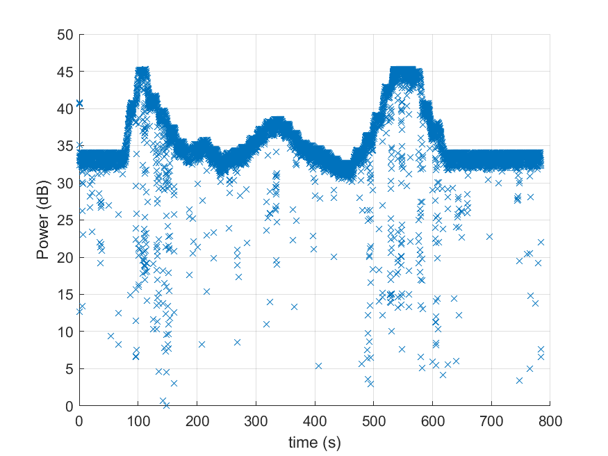
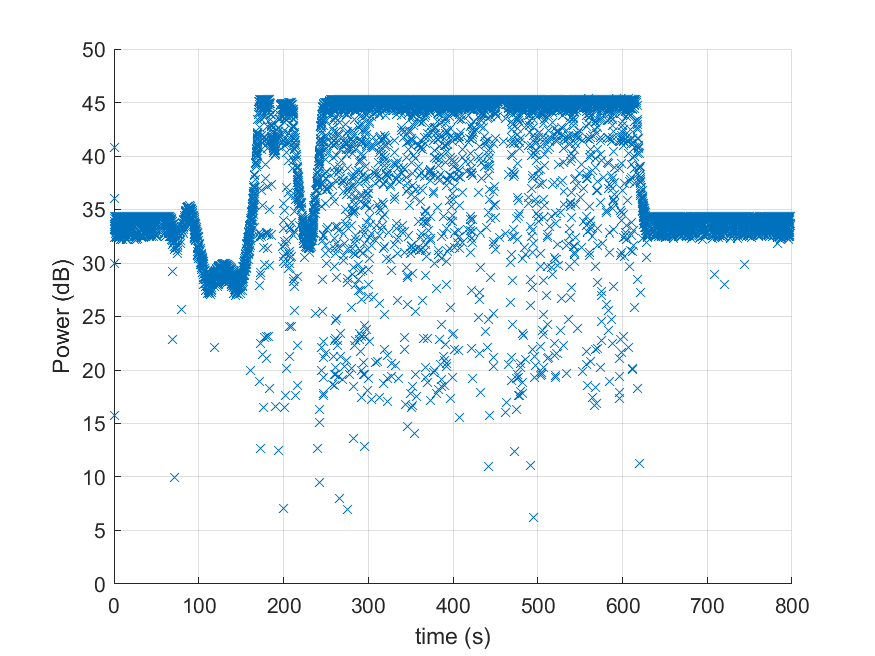
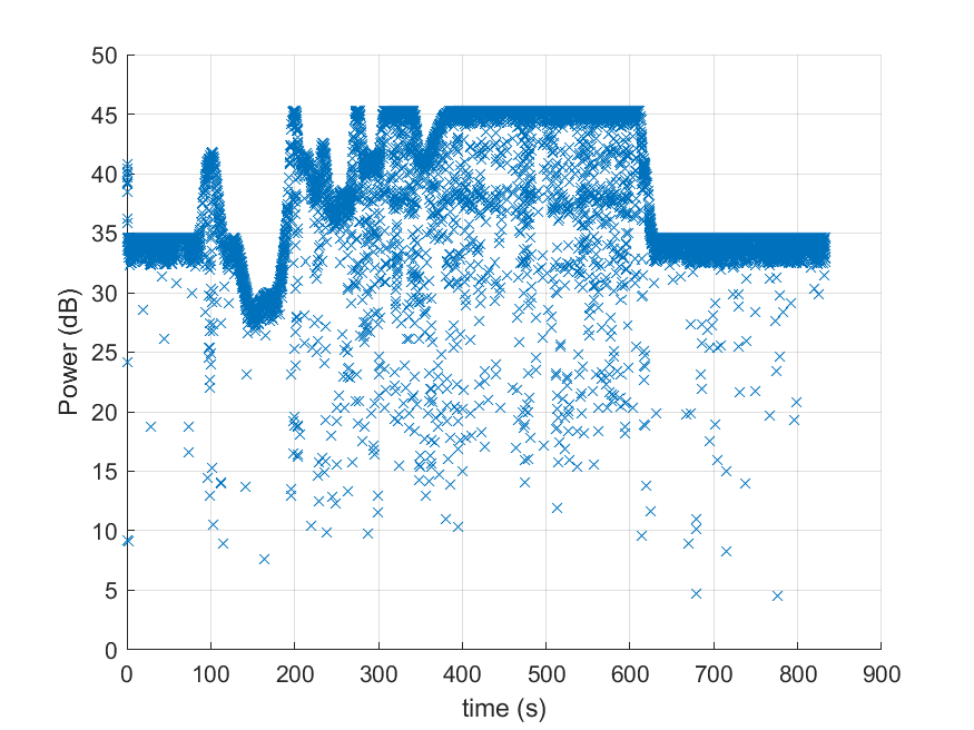
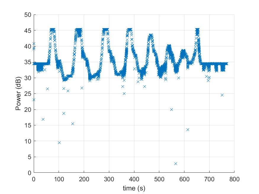
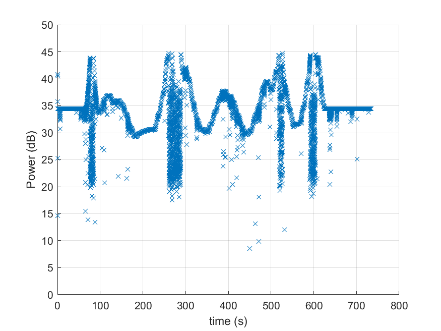
The results of measuring power versus operation time for all teams, during development at location 1, are provided below.
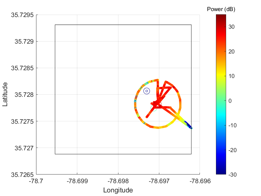
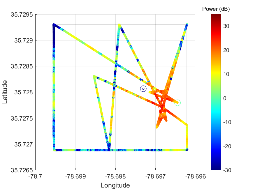
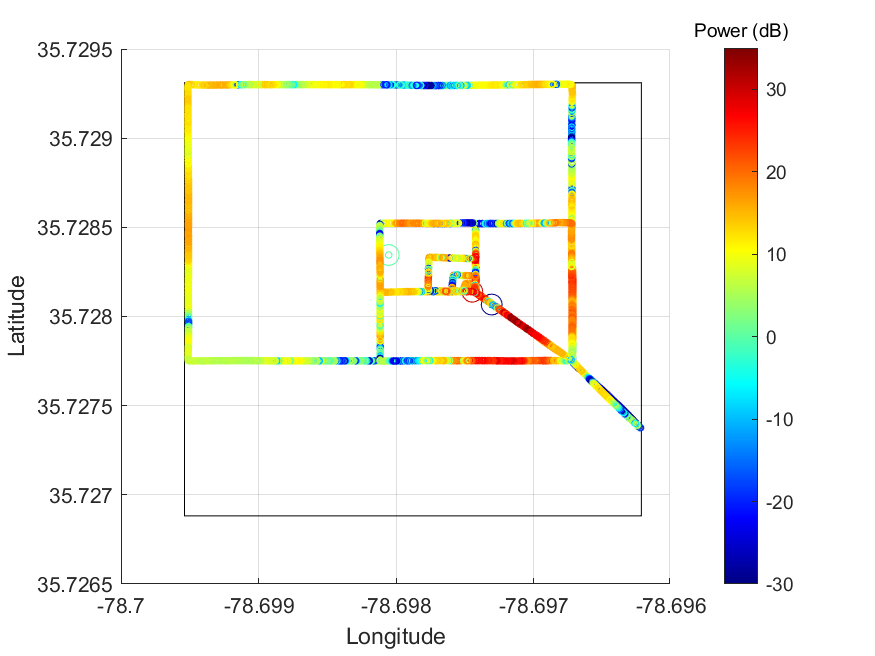
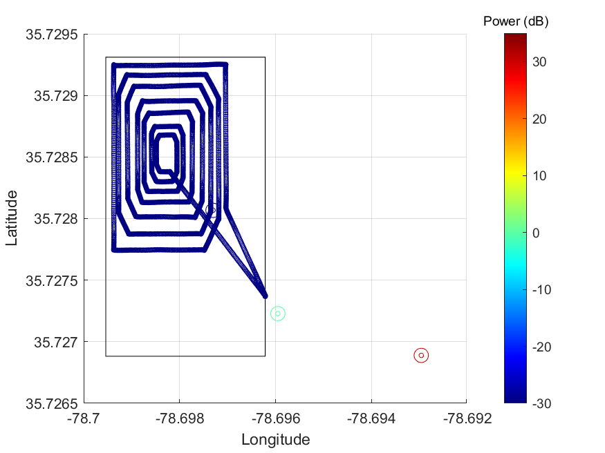
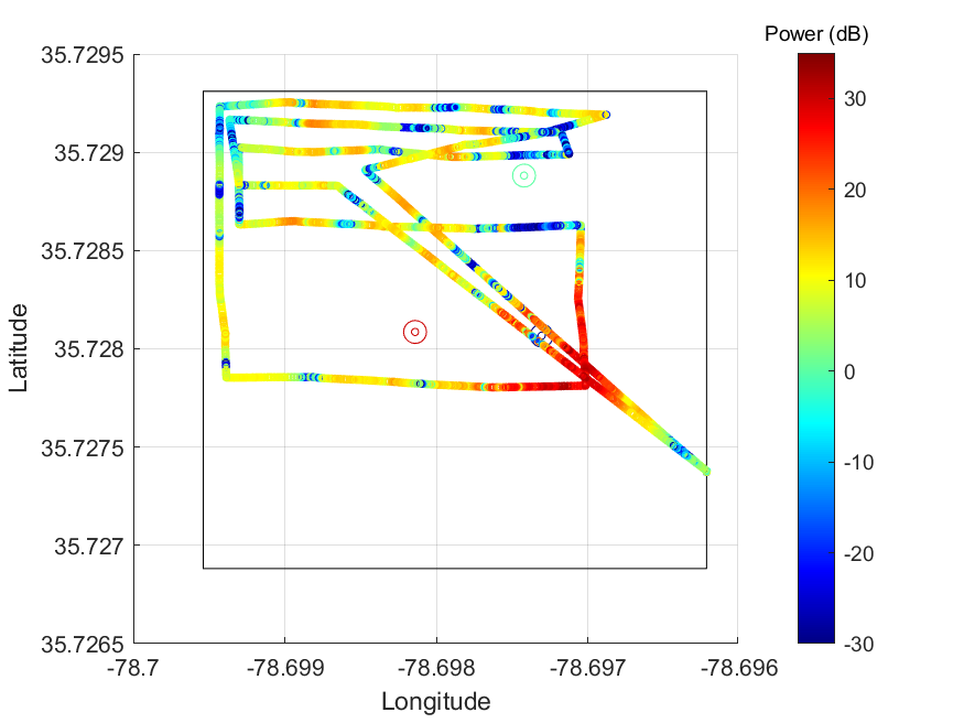
The 3-D scatter plots representing the data for the testbed at location 1 for all teams are provided below.
Potential use cases for this dataset include:
- Search and Rescue Operations
- Autonomous Vehicle Collaboration
- Trajectory Optimization
- Narrowband Propagation Modeling