
Dataset-34: Reinforcement Learning with 3D UAV Network Digital Twin (RL-AERPAW-DT)
Lead Experimenter
Everett Tucker and Yuchen Liu, North Carolina State University
Link to Dataset
The repository provides sample scene and mobility inputs, simulation code, demonstrations, and instructions for generating radio maps. The README describes a downtown Raleigh building scene and a time series of mobile network entities. Users can also supply their own scene XML and pedestrian or vehicle trajectory CSV files. Dataset and source code: https://github.com/EverettTucker471/RL-AERPAW-DT
Equipment and Software Used
Software: NVIDIA Sionna RT, Mitsuba/Blender, SUMO mobility generation, and several simulation and radio-map utilities. The README describes Linux support for the current version. The repository also includes a comparison with an AERPAW path-loss model; the downloadable example is a simulation resource, not a collection of raw radio captures.
Description
RL-AERPAW-DT is an open-source three-dimensional digital twin and dataset for studying UAV-assisted wireless networks. It combines a building scene, moving ground users, UAV localization and radio propagation to simulate link quality and
network performance over time. Its ray-tracing model captures the effect of obstructions on signal-to-noise ratio (SNR), including non-line-of-sight regions that are difficult to represent with a simple path-loss model. The supplied example uses a downtown Raleigh scene and simulated UE trajectories. Researchers can run the environment with those inputs or import a different geographic scene and mobility traces. The framework can generate spatial radio maps of path gain, received signal strength (RSS), and signal-to-interference-plus-noise ratio (SINR). Its demonstrations visualize user assignments, coverage, UAV throughput, and power use as users and UAVs move. The resource supports reproducible studies of UAV placement, trajectory planning, user association, and learning-based control.
Representative Results
The repository compares ray-tracing SNR against an AERPAW path-loss model along a sample UAV trajectory. The two models give similar SNR in the illustrated line-of-sight segment, while ray tracing predicts a substantially lower SNR inside the illustrated obstructed region. Three animated downtown Raleigh demonstrations compare user-assignment strategies and show how throughput, coverage, workload balance, and UAV power consumption evolve over time.
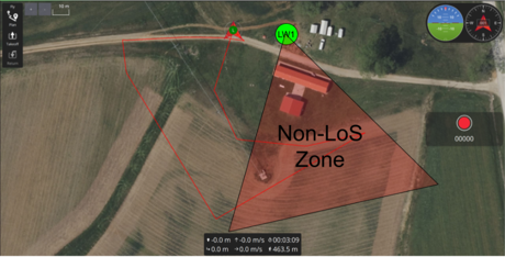
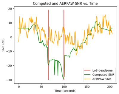
Fig. 1: Sample Experiment Trajectory in the AERPAW Environment, where the UAV trajectory is shown in red as it communicates with LW1 shown in green. In the triangular Non-LoS Zone, the UAV does not have a line-of-sight path to LW1.
Fig. 2: AERPAW and Ray-Tracing Model SNR vs. Time for sample experiment. The yellow line shows AERPAW’s SNR result between LW1 and the UAV at each second, which includes random noise; The green line shows RL-AERPAW-DT’s Ray-Tracing SNR result over the same experiment; The red lines mark the beginning and end of the Non-LoS Zone, where there is no LoS path to LW1 Importantly, both models given similar SNR values when there is a LoS path, but our digital twin model predicts much lower SNR for the non-LoS zone.
Potential use cases of this dataset include:
- UAV trajectory and placement optimization;
- Radio-map generation;
- Reinforcement or meta learning;
- Evaluation under blockage and user mob