
Dataset-12: Rural air-to-ground channel measurements at 3.3 GHz at varying altitudes, signal bandwidths, locations
Lead Experimenter
Ozgur Ozdemir, North Carolina State University
Link to Dataset
- Dataset Link:
The dataset includes UAV propagation data at 3.3 GHz collected at three altitudes (40 m, 70 m, and 100 m), with the 40 m altitude sampled at rates of 5 MHz, 10 MHz, and 20 MHz. Data was recorded in 20 ms intervals every 100 ms using USRP B210 devices at five fixed nodes (LW1-LW5), with IQ samples for two channels captured in each SigMF file, reflecting the dual-channel configuration of the USRPs. The SigMF format dataset including format conversion codes can be accessed here [Dryad].
Publications Using This Dataset
- B. Alkouz, O. Amin, B. Shihada, “Swarm Network-as-a-Service (SNaaS),” arXiv preprint, January 2026.
- M. Rahman, I. Guvenc, J. A. Abrahamson, A. Bhuyan, “Platform and Orientation Aware Channel Knowledge Mapping via Mutual Antenna Pattern Learning in 3D Wireless Links,” IEEE Wireless Communications Letters, January 2026.
- M. Rahman, S. J. Maeng, I. Guvenc, C.-W. Wong, M. L. Sichitiu, J. A. Abrahamson, A. Bhuyan, “UAV-Based 3D Spectrum Sensing: Insights on Altitude, Bandwidth, Trajectory, and Effective Antenna Patterns on REM Reconstruction,” IEEE Sensors Journal, January 2026.
- M. Rahman, I. Guvenc, M. Sichitiu, J. A. Abrahamson, A. Mishra, A. Bhuyan, “Elevation- and Tilt-Aware Shadow Fading Correlation Modeling for UAV-Based Spectrum Sensing,” Proc. IEEE Asilomar Conference, October 2025.
Equipment and Software Used
USRB B205, GNU Radio, UAV
Description
This dataset contains wireless communication signal data collected from an unmanned aerial vehicle (UAV) at different altitudes (40 m, 70 m, and 100 m). For the 40 m altitude, data was collected at varying sampling rates (5 MHz, 10 MHz, and 20 MHz), corresponding to bandwidths of 1.25 MHz, 2.5 MHz, and 5 MHz, respectively. The IQ recordings were made using USRP B210 devices at five fixed nodes (LW1-LW5). The dataset includes IQ samples, GPS coordinates, and received signal strength (RSS) values stored in SigMF format files. A Python script (example.py) is provided for data processing and visualization.
Representative Results
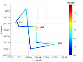
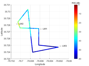
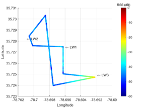
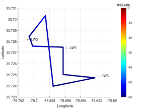
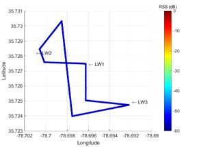
The results from RX Front-End 1 at an altitude of 40 m with a bandwidth of 1.25 MHz for the five fixed nodes are provided below.
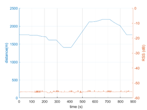
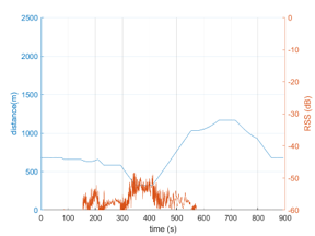
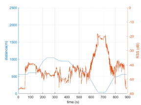
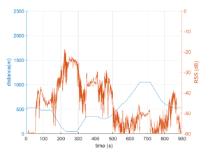
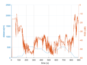
The corresponding RSS values, plotted against longitude and latitude, are presented below for LW1 through LW5, respectively.
Potential use cases for this dataset include:
- Localization and Tracking Systems
- Spectrum Occupancy and RF Environment Analysis
- Localization and Tracking Systems
- Interference Management and Channel Estimation